Speaker 1: (00:00)
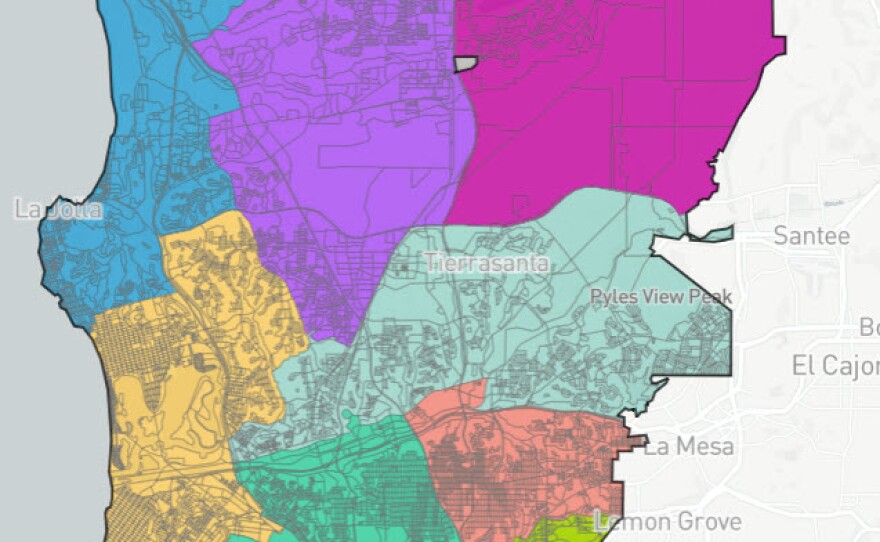
The city of San Diego is moving closer to redrawing the lines for city council districts. A preliminary map was hammered out after public comment. Last week, the volunteer redistricting committee is tasked with using 2020 census numbers to create council districts with a similar number of residents, a population boom in the Northern coastal region of the city means that there will be significant changes in some council boundaries. As some of those proposed changes are drawing criticism, especially when community leaders in Claremont see their neighborhood divided up into four different districts. Joining me is San Diego union Tribune, reporter David Garrick. David, welcome to the program.
Speaker 2: (00:42)
Thanks for having me
Speaker 1: (00:44)
Tell us more about what the aim is and redrawing city council districts has our population shifted significantly since the last census.
Speaker 2: (00:52)
It has, I think more than people had predicted, as you mentioned, north coastal areas, LA Jolla, and that part of town has grown in population. And so has a district three, which is north park, Hillcrest, downtown little Italy. Uh, those two areas have grown a lot and then areas in the Southern part of the city of shrunken population. I wouldn't say significantly, but significantly enough where there's going to be some shifting of these buttons, these boundary lines.
Speaker 1: (01:15)
So last week, the redistricting committee introduced four proposed maps. How do they get synthesized down to this one preliminary map? Well,
Speaker 2: (01:25)
It was an interesting process to watch live. You had these, uh, volunteer commissioners, uh, in the zoom meeting and they were trying to figure out which of the formats they liked, the best they picked. One of them was called map one. Uh, but they decided, well, we have a few problems with it. Let's see if we can solve those. And they spent a lot of time moving a lot of neighborhoods around, and it was a really interesting if you like politics, it was an interesting process to watch, but they went from, uh, one of the proposals map one to the thing that they proposed as a final choice at the end of the interim choice, but a final choice for that meeting. And that's, what's raised so much controversy and Claremont
Speaker 1: (02:00)
Claremont divided up in this proposal.
Speaker 2: (02:02)
It's divided four ways, which as far as we can tell is unprecedented. Since the city went to a district voting in 1988, basically south of bell bowl avenue in east of Tecolote canyon would be in district seven. Uh, south of Balbo and west of the canyon would be in district two, uh, north of Balbo and west of Genesee avenue would be in district one and north of Balbo and east of Genesee avenue would be in district six, which seems kind of crazy. Wow.
Speaker 1: (02:27)
So Claremont community leaders are not pleased with this they're warning. The division will hurt the neighborhood. How would it hurt the neighborhood? Well,
Speaker 2: (02:34)
I think the way that a neighborhood lobbies for things as they talk to their council person and their, that represents their district and they meet with that person and they express their concerns and their desires and their hopes and their dreams to that person and that person lobbies on their behalf at city hall. If your community is divided among four city council districts, then you have four city council people to talk to. Neither one of them cares all that much about you because you're only a small sliver of their district. So it just sort of dilutes the power and influence and the lobbying ability that the community would have.
Speaker 1: (03:04)
The preliminary map also keeps UC San Diego in district one. There has been a big push by some students to move the campus into district six. Is that idea off the table now?
Speaker 2: (03:17)
Definitely not. I mean, I think the folks stress and I try to stress in my stories that they're still working through this. These are all rough drafts, pretty much anything could happen, but obviously neighborhoods like to see how the thing progresses because they want to have whatever they're lobbying for happen. Right now, it looks like the UCLA students that want to be leave. District one are on the wrong side of a victory. There, it looks like they're probably not going to get what they want, but there's definitely more negotiating and more haggling coming in the next 10 days or so I guess November 15th is the deadline that the committee has set for its final.
Speaker 1: (03:48)
One of the reasons students at UC San Diego wanted to move the school from district one to district six is to create a predominantly Asian district in district six. So if you see San Diego doesn't move into district six, will San Diego have a predominantly Asian district?
Speaker 2: (04:05)
You don't say anything. You already has. One district six already is about 34% Asian. The question is, is that enough? Right? I think the folks feel like maybe it should be even more heavily Asian. Uh, and that's what the decision will come down to. If you CSD gets moved into it, at least among the versions I've seen, it gets to about 41, 40 2% Asian. If they keep UCFC in district one, but move some other neighborhoods, it gets to about 38%. So either way, it's going to be more than it is now, which is 34%. The question is how much is enough? And that's sort of a subjective decision. That's on behalf of the commission.
Speaker 1: (04:39)
You've kind of hinted at this, but let me ask you directly, how preliminary is this preliminary council district map? Do members of the redistricting committee say that they are open to making significant changes to the map because they've already made significant changes to create this map in the first place. Right?
Speaker 2: (04:58)
I mean, I guess I would say anything is possible, but I think some of the decisions they made, they feel confident are the right decisions. And there's only so many ways you can do this. Obviously when you come down to moving one street here or there anything could happen, but the general thrust of where they're headed, I think they're kind of on a pathway that they're not going to return from. So I think they're there 85% of the way there. I would say,
Speaker 1: (05:20)
How does the process continue from here?
Speaker 2: (05:22)
And one thing to keep note is that the city council has no role in this. This is an independent commission. So this commission by November 15th, they will have picked a preliminary map. Then they're required a final preliminary map. Then they're required to hold five public hearings on it. And then on December 15th, they will adopt a final map. And that's it. It does not go to the city council. It does not go anywhere else. The only way it could be changes with lawsuits.
Speaker 1: (05:45)
How can people take a look at the preliminary map and form their own opinions and get involved in this?
Speaker 2: (05:51)
Okay, amazing. They have this tool where you can actually make your own map and it's not that hard. You don't have to be technically savvy to really do it. Uh, the city says it has its own redistricting commission website. You go there and you can look at all the maps and then it gives you, it occurs you as you urges you to go in and try to make your own, uh, and study all the numbers and all the math and all the neighborhoods. It's pretty, pretty fascinating.
Speaker 1: (06:13)
Are there any other districts in the city that are getting a major overhaul?
Speaker 2: (06:16)
The district five is, is an interesting one because the Southern edge of, uh, of Rancho Penasquitos park village, which has 10,000 residents was shaved off 10 years ago. Last time this happened and the residents in that neighborhood would strongly want to be reunited with Rancho Penasquitos during the Powell unified school districts together, they say they have a lot in common. That is a key decision that the district commission faces that's actually what got them into trouble. Last Thursday night, they tried to reunite Rancho Penasquitos and they made all these reverberating changes. And that's what sort of led to Claremont being broken up into four parts. So that's another key decision for the district commission to decide.
Speaker 1: (06:54)
I've been speaking with San Diego union Tribune, reporter David Garrick. David. Thank you. Thanks.


