Aerial drones are targeting a new enemy: malaria.
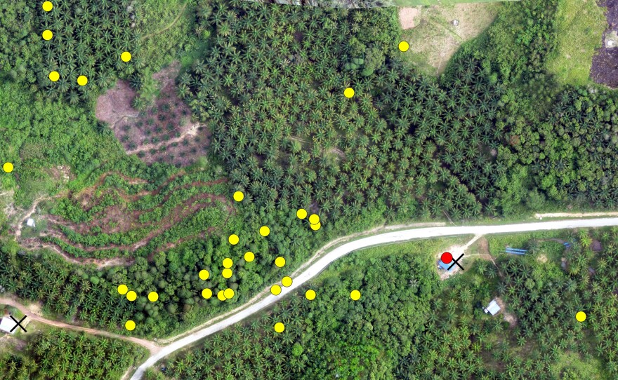
Four hundred feet above a Malaysian forest, a three-foot eBee drone hovers and takes pictures with a 16-megapixel camera every 10 to 20 seconds. But it's not gathering images of the mosquitoes that transmit malaria. Even today's best drones aren't capable of such a photographic marvel. Rather, the drone is looking at a changing landscape that holds clues to the disease's spread.
The malaria drone mission, described in a study published Oct. 22 in Trends in Parasitology, began in December 2013, when UK scientists decided to track a rare strain of the mosquito-borne disease that has surged near Southeast Asian cities. Understanding deforestation may be the key in seeing how this kind of malaria, known as Plasmodium knowlesi, is transmitted.
The mosquitoes that carry P. knowlesi are forest dwellers. The insects breed in cool pools of water under the forest canopy and sap blood from macaque monkeys that harbor the malaria parasite.
In Sabah, Malaysia, human cases of this kind of malaria didn't surface until about 10 years ago, says infectious disease specialist Kimberly Fornace of the London School of Hygiene and Tropical Medicine. She is leading the drone study.
While cases of the most common malaria strains have steadily dropped during this time, P. knowlesi has thrived. It's now the number-one cause of malaria in the region. Fornace and her team suspect that human intrusion into forested areas has created more opportunities for the disease to pass between primates and humans via mosquitoes. The drone imagery they've collected so far suggests there were occasions where land development forced macaques within closer proximity of humans, who then developed malaria.
As part of a project called MONKEYBAR, the team tracks outbreaks by comparing the drone's land surveillance with hospital records of malaria cases. Meanwhile, a local wildlife commission has fitted macaques with GPS collars, which let scientists monitor the locations of monkey troops. Together, this information paints a public health map that explains how land development has influenced monkey movements — and transmission of malaria to humans. In partnership with Conservation Drones, an organization that builds drones for under $1,000, Fornace and her team plan to build a drone that snaps thermal images of macaques, so the monkeys can someday be identified without GPS collars.
Drones provide a better surveillance picture than satellite images, which are the current standard for mapping environmental changes. But Google Earth images, for example, are only updated every few weeks or months, says parasitologist Chris Drakeley of the London School of Hygiene and Tropical Medicine, who coauthored the Trends in Parasitology study with Fornace. Drones, he says, can provide a more comprehensive, continuous picture: "We avoid cloud cover and can see what the land use was like today, next week and the week after."
The public health implications of drone use extend far beyond malaria, says Harvard epidemiologist Nathan Eagle. Doctors have already used unmanned aircraft to carry medical supplies between rural clinics in South Africa and Haiti. Humanitarian drones also tracked property damage and hunted for survivors after Typhoon Haiyan. And when a disease like Ebola surfaces, a drone could scan for changes in bats' habitats, given that the winged mammals are proposed carriers of the hemorrhagic fever. The prices of these drones are dropping while their specs — flight performance and cameras — are improving, says Eagle. All of which means in a few years, a series of very inexpensive aerial vehicles will exist for wider use in public health research.
Copyright 2014 NPR. To see more, visit http://www.npr.org/.


