Play Live Radio
Next Up:
0:00
0:00
Available On Air Stations
Watch Live

Arts & Culture

See the ties that bind Antarctica and Louisiana through one photographer's lens

A view of the glaciers and mountains from the Gerlache Strait on the western side of the Antarctic Peninsula in February 2022.
Tyrone Turner
A view of the glaciers and mountains from the Gerlache Strait on the western side of the Antarctic Peninsula in February 2022.

Editor's note: As the 2022 U.N. Climate Change Summit convenes, NPR's Picture Show is featuring work by photographers that highlights the effects of climate change around the world.

As frigid wind whipped across the ship's bow, I held the railing with one hand and steadied my camera with the other. In front of me stretched the Bellingshausen Sea, off the coast of Western Antarctica. I was there — my second journey to the region around the southernmost continent — early this year on a five-week voyage as a photographic expert aboard the National Geographic Endurance. A small group of passengers and I stood on the deck together, wrapped up tightly against the below-freezing temperatures, documenting this otherworldly landscape.

Pancakes of sea ice covered the waters as far as the eye could see. A lone emperor penguin tucked its head into its chest of feathers. As we sailed past seals resting on the ice, they raised their heads and promptly slid into the water. This frozen world seemed so different and foreboding — and yet, at the same time, familiar. In a strange way, I felt connected to my subtropical birthplace thousands of miles away — in the coastal regions of southeastern Louisiana.
Advertisement
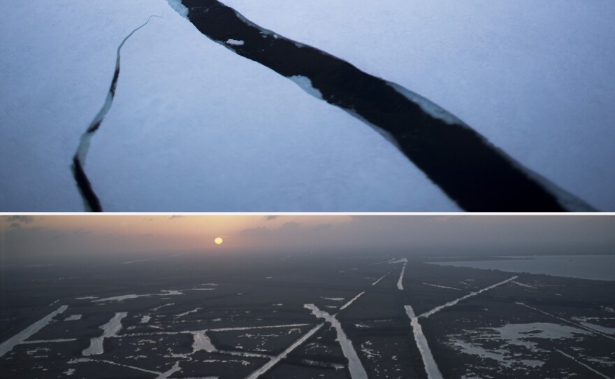
(Top image) Cracks in sea ice extend from the ship's bow in the Lemaire Channel of the Antarctic Peninsula in November 2017. (Bottom image) Oil and gas pipeline and exploration canals cut into the marshlands near Larose, La., in November 2006.
Tyrone Turner
(Top image) Cracks in sea ice extend from the ship's bow in the Lemaire Channel of the Antarctic Peninsula in November 2017. (Bottom image) Oil and gas pipeline and exploration canals cut into the marshlands near Larose, La., in November 2006.

The diptychs in this essay portray this connection by pairing my images of Antarctica with those of Louisiana. It is a visual dance of rhythms and patterns of two places so far apart, and yet whose fates are inextricably linked. Because, for me, combining photographs from the two enhances my understanding of each one. Beyond connecting the two places, it's also an exercise of connecting our actions to consequences far into the future and across the globe.
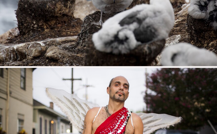
(Top image) A black-browed albatross fledgling on the Falkland Islands exercises its wing spread in preparation for a life of long-distance flying in February 2022. (Bottom image) I saw Pete with his wings in the Faubourg Marigny of New Orleans in July 2015 and had to negotiate a u-turn to ask if I could take his photo. He said he was a professional Greek dancer.
Tyrone Turner
(Top image) A black-browed albatross fledgling on the Falkland Islands exercises its wing spread in preparation for a life of long-distance flying in February 2022. (Bottom image) I saw Pete with his wings in the Faubourg Marigny of New Orleans in July 2015 and had to negotiate a u-turn to ask if I could take his photo. He said he was a professional Greek dancer.
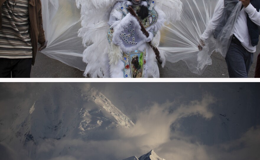
(Top image) Spyboy Al Polite of the Mardi Gras Indian tribe Fi Yi Yi walks through the streets of downtown New Orleans on Carnival Day, February 2013. (Bottom image) A view of the glaciers and mountains from the Gerlache Strait on the western side of the Antarctic Peninsula in February 2022.
Tyrone Turner
(Top image) Spyboy Al Polite of the Mardi Gras Indian tribe Fi Yi Yi walks through the streets of downtown New Orleans on Carnival Day, February 2013. (Bottom image) A view of the glaciers and mountains from the Gerlache Strait on the western side of the Antarctic Peninsula in February 2022.

I grew up along New Orleans' 17th Street canal, running along levees and paddling pirogues in search of turtles. My brother and I watched otters play in the brackish water of a nearby swamp. Bayous and marshes bisected and surrounded the city as well as our daily lives. Over the past 20 years, I've documented the rich culture of my hometown and the coastal wetlands of Louisiana, photographing the impact of disasters on the environment and the communities it sustains.

Hurricane Katrina — once such disaster — ravaged the Gulf Coast in 2005, killing more than 1,800 people. The storm destroyed 30 square miles of coastal wetlands and burst through New Orleans' levees, flooding 80% of the city.
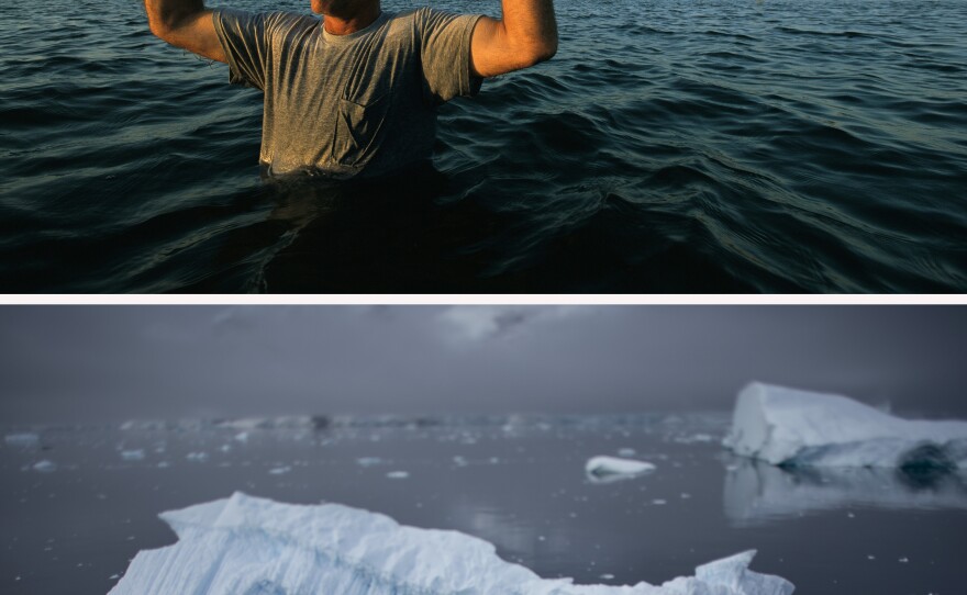
(Top image) Pete Vujnovich Jr. holds a photo of what was once his grandparents' home as he stands in that spot in the marshlands near Empire, La., in May 2004. (Bottom image) Icebergs float on the Lemaire Channel waters off the Antarctic Peninsula in January 2022. The increase in sea level rise from glacial runoff has the potential to overwhelm coastal regions around the world.
Tyrone Turner
(Top image) Pete Vujnovich Jr. holds a photo of what was once his grandparents' home as he stands in that spot in the marshlands near Empire, La., in May 2004. (Bottom image) Icebergs float on the Lemaire Channel waters off the Antarctic Peninsula in January 2022. The increase in sea level rise from glacial runoff has the potential to overwhelm coastal regions around the world.
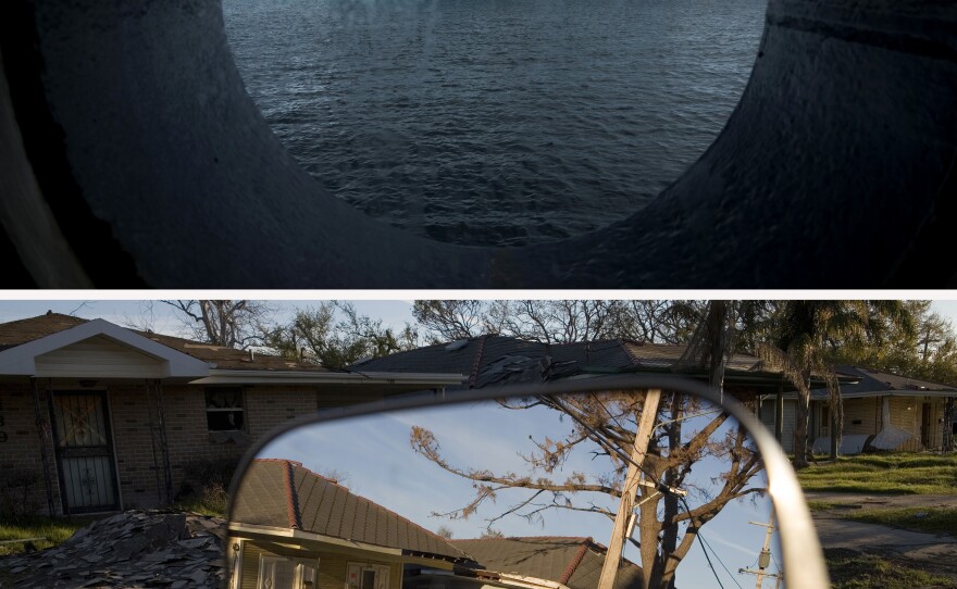
(Top image) An iceberg floats in Wilhelmina Bay on the west side of the Antarctic Peninsula in November 2017. (Bottom image) Flood-damaged homes in the Lakeview area of New Orleans in March 2006. More than 80% of the city was flooded by the Hurricane Katrina stormwaters. Sea level rise and super-charged storm surges put low-lying communities around the world at risk.
Tyrone Turner
(Top image) An iceberg floats in Wilhelmina Bay on the west side of the Antarctic Peninsula in November 2017. (Bottom image) Flood-damaged homes in the Lakeview area of New Orleans in March 2006. More than 80% of the city was flooded by the Hurricane Katrina stormwaters. Sea level rise and super-charged storm surges put low-lying communities around the world at risk.

Five years later, the BP oil disaster killed 11 rig workers and pumped four million barrels of crude oil into the Gulf of Mexico — the largest oil spill in U.S. marine history. Hundreds of miles of fragile Louisiana coast were coated. The oil suffocated the vulnerable marsh grasses, whose roots hold the land in place. The vegetation died and the mud washed away, increasing existing coastal erosion by almost 300%, according to researchers at Louisiana State University.
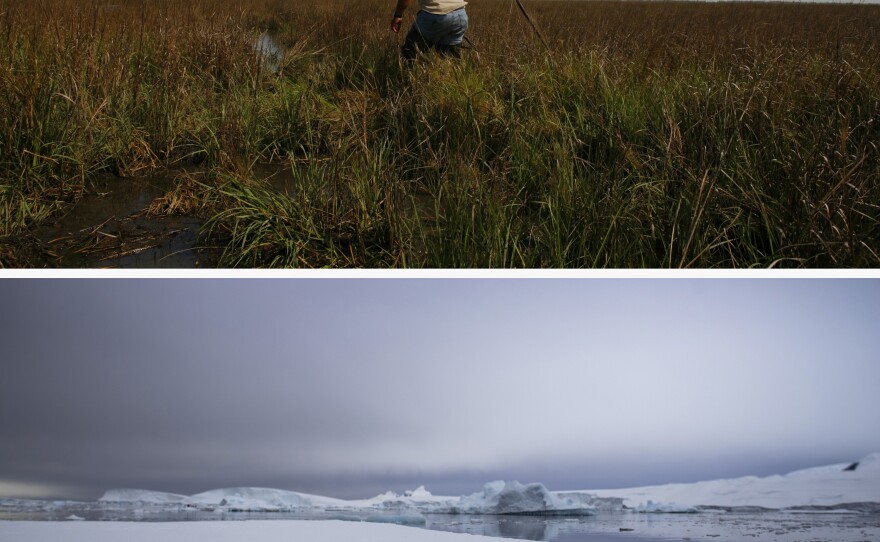
(Top image) Maurice Phillips walks through marsh grass near his home in Grand Bayou, southeast of New Orleans, in March 2006. The village is only accessible by boat and is increasingly vulnerable to storm surge because of the loss of the surrounding wetlands. (Bottom image) Adelie penguins walk on sea ice near the Fish Islands in the Antarctic Peninsula in February 2022.
Tyrone Turner
(Top image) Maurice Phillips walks through marsh grass near his home in Grand Bayou, southeast of New Orleans, in March 2006. The village is only accessible by boat and is increasingly vulnerable to storm surge because of the loss of the surrounding wetlands. (Bottom image) Adelie penguins walk on sea ice near the Fish Islands in the Antarctic Peninsula in February 2022.

Long ago, ice shaped Louisiana. As the last ice age in North America retreated more than 12,000 years ago, melting glacial runoff carved out the Mississippi River basin. For thousands of years after that, the seasonal unfettered flooding of the Mississippi deposited sediment in the low delta region and built up the southern part of the state. Starting in the late 19th century, Congress tasked the U.S. Army Corps of Engineers with building levees to control the river to improve navigation and provide for flood protection. Paradoxically, what seemed good for urban expansion and industrialization along the Mississippi River gradually starved the wetlands of the sediment needed to rebuild and counteract natural subsidence.
Advertisement
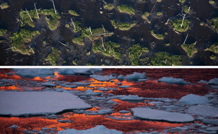
(Top image) A May 2006 aerial view of marshlands near Empire, La. Since the 1930s, the state has lost about 2,000 square miles of land, the highest rate of land loss in the United States. (Bottom image) The warm light of an Antarctic sunset bathes sea ice floating in the Lemaire Channel in January 2022.
Tyrone Turner
(Top image) A May 2006 aerial view of marshlands near Empire, La. Since the 1930s, the state has lost about 2,000 square miles of land, the highest rate of land loss in the United States. (Bottom image) The warm light of an Antarctic sunset bathes sea ice floating in the Lemaire Channel in January 2022.

Antarctica and Louisiana share a history of extractive industries in search of fuel. At the same time the Corps was beginning its work on the Mississippi, Antarctic whales were being hunted for the oil extracted from their blubber. Over the following century, commercial whaling expanded to such an extent that several species were nearly killed off.

In the 20th century, the oil and gas industry carved up Louisiana's coastal marshes with thousands of exploration canals, accelerating erosion. The combination of levees, canals and natural subsidence all contributed to coastal land loss and reduced critical protection against hurricane storm surges. Presently, the state loses a football field's worth of land every 100 minutes, according to the U.S. Geological Survey.

The warming climate is affecting the polar regions, especially in the Arctic. However, runoff from Antarctic ice currently makes up 20-25% of global sea level rise. And warming and expanding oceans will only accelerate the glacial ice sheets' decay. As sea levels rise, scientists predict low-lying coastal areas around the world will increasingly be overwhelmed. This is true for my home state, where wetlands are the primary defense against storm surges. And levees alone will not hold back the rising waters.
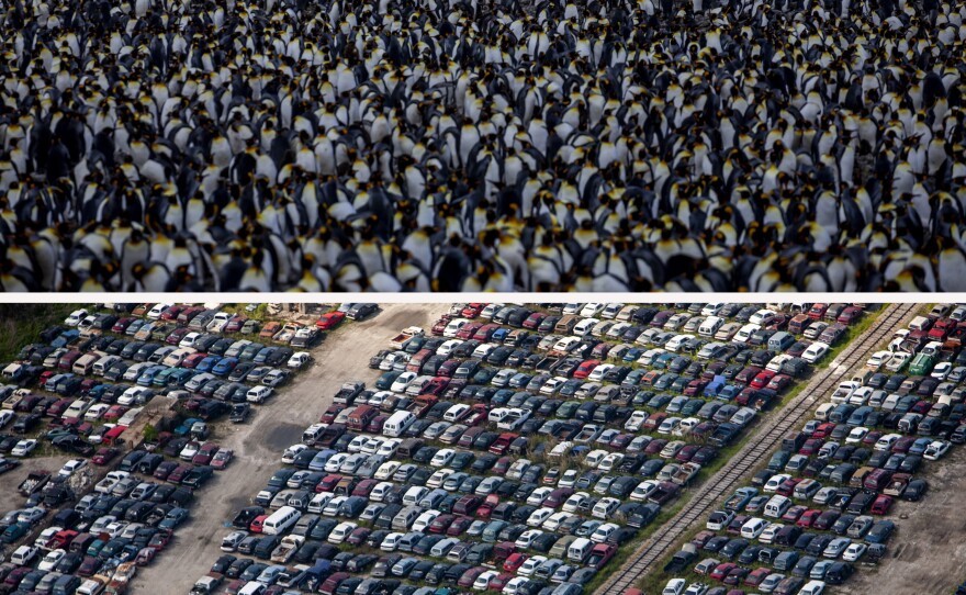
(Top image) A king penguin colony on the South Georgia Island's in February 2022. Scientists warn that, in the future, warming oceans and commercial fishing could negatively affect the penguins' food sources. (Bottom image) An aerial photo of thousands of cars flooded by Hurricane Katrina near New Orleans in April 2007.
Tyrone Turner
(Top image) A king penguin colony on the South Georgia Island's in February 2022. Scientists warn that, in the future, warming oceans and commercial fishing could negatively affect the penguins' food sources. (Bottom image) An aerial photo of thousands of cars flooded by Hurricane Katrina near New Orleans in April 2007.

As we sailed through the Bellingshausen Sea, I marveled at the textured beauty of the frozen watery landscape. But it also felt as if a rope was running from the Antarctic ice in front of the ship to the coastal waterways of Louisiana so far away — it felt like what we've done, as humans, to accelerate climate change has pulled that rope taught. There is no slack, no lag time, between existential changes in one place on Earth and the effects those will have on another. Tug on one side, and the other will fall.
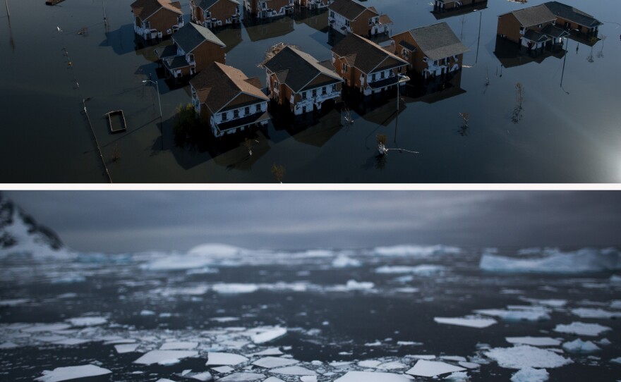
(Top image) A September 2005 aerial photo of a flooded New Orleans in the days following Hurricane Katrina. The storm's surge of floodwaters burst through levees, killing more than 1,800 people and flooding 80% of the city. (Bottom image) Fractured sea ice near the western coast of the Antarctic Peninsula in November 2017.
Tyrone Turner
(Top image) A September 2005 aerial photo of a flooded New Orleans in the days following Hurricane Katrina. The storm's surge of floodwaters burst through levees, killing more than 1,800 people and flooding 80% of the city. (Bottom image) Fractured sea ice near the western coast of the Antarctic Peninsula in November 2017.
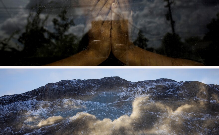
(Top image) A portrait of Everidge Green Jr., 6 years old, in the window of his grandfather's rebuilt home in New Orleans in August 2014. His older cousin and great grandmother died in the floodwaters of Hurricane Katrina in August 2005. (Bottom image) The mountains of South Georgia and clouds are reflected in the windows of the National Geographic Endurance in February 2022.
Tyrone Turner
(Top image) A portrait of Everidge Green Jr., 6 years old, in the window of his grandfather's rebuilt home in New Orleans in August 2014. His older cousin and great grandmother died in the floodwaters of Hurricane Katrina in August 2005. (Bottom image) The mountains of South Georgia and clouds are reflected in the windows of the National Geographic Endurance in February 2022.
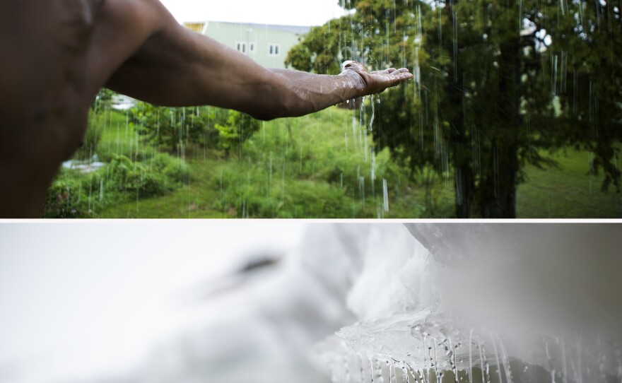
(Top image) Robert Green Sr., the grandfather of Everidge Green Jr. in the previous photo, reaches out to touch the rain falling around his rebuilt home in New Orleans' Lower Ninth Ward in August 2014. (Bottom image) Meltwater runs off a shelf of ice and snow on Horseshoe Island in the Antarctic Peninsula's Marguerite Bay in March 2022.
Tyrone Turner
(Top image) Robert Green Sr., the grandfather of Everidge Green Jr. in the previous photo, reaches out to touch the rain falling around his rebuilt home in New Orleans' Lower Ninth Ward in August 2014. (Bottom image) Meltwater runs off a shelf of ice and snow on Horseshoe Island in the Antarctic Peninsula's Marguerite Bay in March 2022.

Vanessa Castillo photo edited this story.

Zach Thompson text edited this story.

Tyrone Turner is a photographer whose work has explored the relationship between humans and the environment for nearly two decades. He is currently a visual storyteller and editor with WAMU and DCist in Washington, D.C. Follow him on Instagram at @tyronefoto.

Copyright 2023 NPR. To see more, visit https://www.npr.org.