Updated at 2 a.m. ET Monday
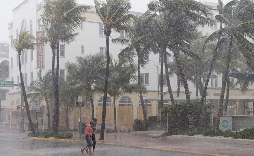
Irma has weakened since beginning its push up central Florida, but is still a Category 1 hurricane with winds near 85 mph and higher gusts, according to the National Hurricane Center. Its center is about 25 miles northeast of Tampa and continues to move toward the north-northwest. The NHC says Irma is expected to turn northwest later today and further weaken to a tropical storm.
Irma's hurricane force winds extend at least 80 miles from the storm's center and tropical storm force winds extend as far as 415 miles. The hurricane is forecast to reach the southeastern United States later tonight.
The NHC warns coastal areas could see rising water moving inland over the next 36 hours. "This is a life threatening situation," it said in a bulletin issued at 2 a.m. ET.
Hurricane Irma had touched land again as a Category 3 Sunday afternoon, hitting Marco Island on Florida's southwest coast, after it plowed through the Florida Keys as a Category 4 earlier in the day.
Miami International Airport announced it will remain closed to passenger flights at least through Monday, though some airlines will fly personnel to the airport in preparation for reopening. The airport's director, Emilio Gonzalez, said via Twitter that the airport had endured wind gusts near 100 mph and "sustained significant water damage throughout."
"The interaction with the Florida Peninsula along with strong southwesterly shear should cause significant weakening, but Irma's large and powerful circulation will likely maintain hurricane strength until Monday morning at the earliest," according to the National Hurricane Center's latest forecast.
Residents across the state, from the southernmost tip of the peninsula to areas near Florida's northern border, now face what the NHC called a "life threatening" storm surge.
"(T)he wind direction will shift to onshore, causing water levels along the southwest coast of Florida to rapidly rise in a matter of minutes. MOVE AWAY FROM THE WATER!," the NHC said in a statement Sunday afternoon.
Gov. Rick Scott warned that it would be storm surge, more so than winds or power outages, that would likely be the most dangerous aspect of Irma over the coming days.
"Ten to 15 feet above ground level — even 5 or 6 feet — it's hard to believe anybody will survive that," Scott told NBC on Sunday morning. "It comes into your house; it flushes in, it flushes out. And that's going to be very difficult to survive."
Districtwide, the South Florida Water Management District projected between 5.5 and 6 inches of rain for Sunday. That amount would top the single-day record of 5.35 inches, set by Tropical Storm Mitch in November 1998. On Sunday, Collier and Lee counties were expected to see the heaviest rainfall, with an average of 8-12 inches.
President Trump granted a major disaster declaration to assist with recovery efforts in Florida, the White House said in a statement, approving Gov. Rick Scott's request for federal assistance earlier Sunday.
"The President's action makes Federal funding available to affected individuals in the counties of Charlotte, Collier, Hillsborough, Lee, Manatee, Miami-Dade, Monroe, Pinellas, and Sarasota," the statement reads.
A beaten path through the Florida Keys
Irma plowed into the lower Florida Keys early Sunday morning, its eye passing just 20 miles east of Key West.
By 3:50 a.m. Sunday, the National Weather Service in Key West recorded water levels of 2 feet above normal, with Scott tweeting that the Keys "are getting gusts of hurricane force winds now- more expected. Stay indoors and be safe."
And just after 6 a.m., the National Weather Service in Key West made the urgency of the situation quite clear, issuing an "extreme wind warning" and writing: "This is an extremely dangerous and life-threatening situation!"
"The problem is that the Keys are a very low-lying chain of islands, so there's nowhere that's truly safe from a devastating storm surge, plus there's only one road out of the Keys," Nancy Klingener of member station WLRN reported from Key West.
She was in a three-story concrete building that she said was shaking a bit from wind gusts Sunday morning.
And she was not alone in the area.
For some who remained on the Keys, evacuation was no longer an option on Sunday morning. "STAY INSIDE & HUNKER DOWN," the weather service warned those residents, advising them to move away from windows and cover themselves in pillows and blankets to deflect possible debris.
A Twitter user posted video that purported to show the scene in Key West:
Impact on the mainland
Utility officials log as many as 3.3 million Floridians without power, according to The Associated Press. After restoring more than 300,000 outages, main provider Florida Power & Light says Irma has left roughly 1.7 million of its customers without power, and the state's Division of Emergency Management says its more than 609 shelters are filling with an evacuee population stretching into the six digits.
For others, like a Tampa neighbor of WUSF's Tyler Kline, preparations meant pulling wood from their own fence just to board up their windows.
All told, more than 6 million Floridians have been warned to evacuate — more than a quarter of the state's population and one of the biggest evacuations in Florida history. Many heeded that request — but were stuck on clogged highways. Some gas stations in South Florida ran out of fuel and couldn't keep up with demand.
As Gov. Scott noted, some of the greatest concern rests with the expected storm surge. The National Hurricane Center warned it could reach as high as 10 to 15 feet in the coastal area spanning from Cape Sable and Captiva on Florida's southwestern coast. Most of the coast of the entire state was under storm surge warnings, as well.
"You could have it where the second story of some buildings is going to get inundated," NHC meteorologist David Zelinsky told NPR's Windsor Johnston. He added that storm surge flooding is responsible for more than half of the deaths during hurricanes.
The NHC predicted the storm would weaken — it had at one point clocked wind speeds of 185 mph — though it would "remain a powerful hurricane as it moves through the Florida Keys and ... near the west coast of Florida."
On Sunday morning, the NHC predicted Irma would move "near or along the west coast of Florida" through Monday morning, before hitting parts of the Florida Panhandle and southwest Georgia later Monday. Maps show it later touching parts of Alabama, Mississippi and Tennessee.
For now, though, residents in western Florida are scrambling to prepare. Residents in Miami had been expecting the brunt of the storm, but the storm's expected path then shifted to the northwest, taking many people by surprise.
"Last night there was panic because Tampa was a place people were escaping to, a place they thought would be a refuge," reports NPR's Leila Fadel. "And then this monster of a storm shifted and headed west and the city and the evacuees who came here are grappling with the fact that they might be smack-dab in the middle of this terrifying weather."
Fadel described "dazed couples" at a city hotel and staff looking "exhausted, answering panicked customers, constant phone calls and thinking about securing their own homes and families."
Almost half the gas stations in Tampa were out of gas, leading to confrontations as other supplies ran low. "People here fight for like everything," Joanna Ruisanchez, who works at a Shell gas station there, told NPR's Abby Wendle. "They'll come and like, curse us out."
Deadly car crash
Earlier on Sunday morning in Hardy County, while some were still preparing for Irma, a sheriff's deputy and a corrections officer died following a car crash. Hardee County Sheriff Arnold Lanier confirmed the deaths with NPR. Deputy Julie Bridges, 42, was driving her patrol car on her way home to pick up supplies for an evacuation shelter where she'd been working.
About 6:45 a.m. Bridges' car crashed into another vehicle driven by a corrections officer who was on his way to work, according to Lanier. Bridges was a 13-year veteran of the sheriff's office.
Meanwhile, the National Weather Service has warned of tornadoes, especially east of the hurricane's path.
President Trump has been keeping abreast of the storm Sunday, speaking with the governors of Alabama, Georgia, South Carolina and Tennessee, according to White House press secretary Sarah Huckabee Sanders.
"He's spoken numerous times to Gov. Scott and Sen. Rubio of Florida over the last week, as has Gen. [John] Kelly," Sanders said. "The chief of staff also spoke to Sen. Nelson of Florida this morning."
NPR's Maquita Peters contributed to this report.
Copyright 2017 NPR. To see more, visit http://www.npr.org/.


