Updated at 11:50 a.m. ET
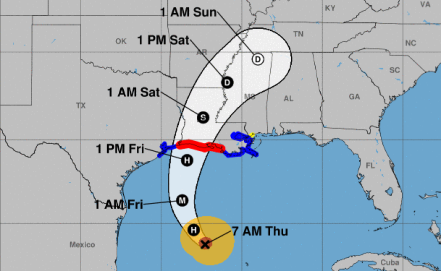
A large part of Louisiana's coast is under a hurricane warning, as Hurricane Delta heads toward an expected landfall Friday afternoon. The storm has 105 mph winds, but it's expected to strengthen into a major hurricane – and then possibly weaken again — before hitting land.
Water from the hurricane's storm surge could reach as high as 7 to 11 feet in areas from Pecan Island, La., to Port Fourchon, La., according to the National Hurricane Center. Delta is forecast to intensify, with sustained winds up to 115 mph.
"Today's your day to get ready," NHC Director Ken Graham told people in the storm's expected path, in an online briefing Thursday morning. Floodwaters and high winds could arrive ahead of landfall, making it too dangerous to prepare or evacuate as the storm approaches on Friday, Graham said.
"If ordered to evacuate by local officials, leave!" the National Weather Service office in New Orleans warned residents on Thursday.
Delta is currently a Category 2 storm. Its possible path includes Cameron, La., and other areas just east of the Texas border – many of which are still recovering from a devastating blow dealt by Hurricane Laura, a Category 4 storm, in late August.
"We have until nightfall to make sure that we take care of what we need to before we start feeling the effects of this storm," Louisiana Gov. John Bel Edwards said Thursday morning via Twitter. "Let's make it count."
President Trump approved Edwards' request for a federal emergency declaration on Wednesday.
A hurricane warning is in effect from east of Sabine Pass, at the Texas-Louisiana border, to Morgan City, La., south of Baton Rouge. A storm surge warning covers a wider area, extending to Ocean Springs, Miss. The storm will bring torrential rains of 5 to 10 inches, with some areas seeing up to 15 inches, the hurricane center says.
"Significant flash, urban, small stream and minor to isolated moderate river flooding is likely Friday and Saturday from portions of the central Gulf Coast into portions of the Lower Mississippi Valley," the center said. "As Delta moves farther inland, heavy rainfall is expected in the Ohio Valley and Mid-Atlantic this weekend."
Delta is smaller and less powerful than Laura, although the hurricane is expected to grow larger as it crosses the Gulf of Mexico. It is projected to have hurricane-force winds for up to 35 miles from its center and tropical-storm-force winds for up to 125 miles.
While Delta is a well-organized system, it has mostly lacked the clear eye that most hurricanes have. It finally showed signs of developing an eye on Thursday.
The NHC says NOAA and Air Force Hurricane Hunter planes will investigate Delta on Thursday to learn more about its structure.
Copyright 2020 NPR. To see more, visit https://www.npr.org.


